You are here
Back to topCentral & Eastern Florida Regional Map (Folded)
$7.69
This item is not available this time
This item is not available this time
Description
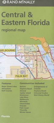
Rand McNally's folded map for Central & Eastern Florida is a must-have for anyone traveling in and around this area, offering unbeatable accuracy and reliability at a great price. Our trusted cartography shows all Interstate, U.S., state, and county highways, along with clearly indicated parks, points of interest, airports, county boundaries, and streets. The easy-to-use legend and detailed index make for quick and easy location of destinations. You'll see why Rand McNally folded maps have been the trusted standard for years.
Regularly updated
Full-color maps
Clearly labeled Interstate, U.S., state, and county highways
Indications of parks, points of interest, airports, county boundaries, downtown & vicinity maps
Attractions & golf cources
Enlagements of Orlando, Daytona Beach, Universal Studios, & Walt Disney World
Detailed & full street index
Coverage Area
Communities Included: Bartow, Daytona Beach, DeLand, Jupiter Beach, Kissimmee, Lake Mary, Melbourne, Minneola, Okeechobee, Orlando, Palm Coast, Titusville, Winter Haven
Product Details
Measures 9.5' x 4' and folds out to 40' x 28'.